
Proposed Balamballe Airport Design and Development Project …
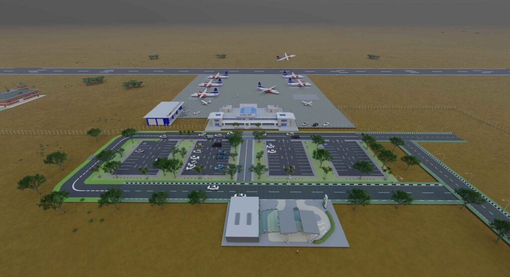
Project Location: Balamballe District, Galguduud Region, Galmudug State, SomaliaProject Reference: BALAMBALLE-005Design Date: December 2021Project Type: Airport planning, civil engineering design and runway developmentClient/Beneficiary: Balamballe District CommunityProject Status: Proposed design with initial site and runway preparation activities Project Overview The Proposed Balamballe Airport Project is an important infrastructure initiative developed to improve transportation, accessibility and economic opportunities for the people of Balamballe District and the wider Galguduud region of Somalia. The project was planned as a community-focused airport development designed to provide a safe and organized aviation facility for Balamballe. The proposed airport will support passenger movement, emergency services, humanitarian operations, government activities, business travel and the transportation of essential goods. Located in Balamballe District in Galmudug State, the project responds to the growing need for reliable air connectivity between the district and other parts of Somalia. Road transportation across central Somalia can be affected by long travelling distances, difficult terrain and seasonal weather conditions. A properly developed airport can significantly reduce travel time and provide an alternative means of transportation for the local community. The airport design was prepared under Project Number BALAMBALLE-005 and includes the principal planning, civil engineering and standard construction drawings required to guide the proposed development. Project Vision The main vision of the project is to establish a safe, functional and expandable airport that can serve the current and future transportation needs of Balamballe District. The airport master plan was developed to organize the runway, apron, terminal facilities, access roads, parking areas, security infrastructure and supporting services within one coordinated site layout. The proposed arrangement also considers the possibility of future expansion as passenger demand, commercial activity and aviation services increase. The project is intended to become an important public infrastructure asset for Balamballe and surrounding communities. Beyond supporting aviation, the development can help attract investment, improve government and humanitarian access and create new employment opportunities during construction and airport operations. Engineering Design Scope The proposed design package covers the main technical components required for airport planning and civil works. The general documentation includes the project cover information, drawing abbreviations and general engineering notes. These documents provide the standards, references and instructions required to understand and implement the design. The mapping and planning section includes the airport master plan, general site topography and runway charts. The topographical information is essential for understanding the existing ground elevations, natural drainage patterns and physical conditions of the site. The airport master plan coordinates all major facilities and shows how the different operational areas will function together. The civil engineering drawings include the runway plan and profile, typical cross-sections, apron details and fence-wall details. These drawings provide guidance for site preparation, earthworks, levels, runway formation, pavement construction and security boundaries. Standard drawings were also prepared for the runway’s typical layout, typical cross-section and turnpad arrangement. The turnpad is intended to provide an area where aircraft can safely turn at or near the end of the runway. Proposed Airport Facilities The conceptual design presents a complete airport layout rather than only a runway. The proposed development includes the runway, aircraft apron, terminal-related buildings, access roads, vehicle parking, landscaped areas, airport service facilities and perimeter security. The runway forms the central operational element of the project. It is planned to provide a prepared and clearly defined surface for aircraft take-off and landing. Its alignment was selected in relation to the available land, surrounding terrain and the overall airport master plan. The apron is positioned near the terminal area to provide space for aircraft parking, passenger boarding, unloading and ground-handling activities. The apron layout is designed to allow several aircraft to be accommodated while maintaining organized movement between the runway and terminal facilities. The proposed terminal zone includes passenger-handling buildings and related operational facilities. The design also provides vehicle circulation routes and parking areas to separate airport traffic from aircraft operations. Landscaped areas and organized access roads have been incorporated into the concept to create an attractive and functional entrance to the airport. The overall arrangement is intended to improve passenger experience while maintaining safety and operational control. Runway and Site Preparation Activities The project photographs show important early-stage activities associated with runway and airfield development. Initial works included site clearing, grading, watering and compaction of the runway formation. These activities are necessary to create a stable, level and well-compacted platform before the final runway pavement layers are constructed. Motor graders were used to spread and level the prepared material across the runway area. Grading helps establish the required surface profile, longitudinal levels and crossfall. Correct levels are particularly important for runway safety and stormwater drainage. Water tankers were used to apply controlled moisture to the construction material. Moisture conditioning is an important part of earthwork compaction because soil and selected fill materials must contain an appropriate amount of moisture to achieve the required density. Rollers and compaction equipment were then used to compact the prepared surface. Proper compaction reduces settlement, improves bearing capacity and provides a stable foundation for the upper pavement layers. The photographs also demonstrate the scale and width of the prepared runway corridor. The works were carried out over a wide, open site with sufficient space for construction machinery, runway development and future airport facilities. Earthworks and Pavement Formation Airport runways require carefully controlled earthworks because aircraft operations produce significant loads that must be safely transferred through the pavement structure into the underlying ground. The site-preparation process generally begins by removing unsuitable materials and clearing the proposed runway area. The natural ground is then shaped according to the approved runway profile. Where required, suitable fill material is placed in controlled layers. Each layer must be spread evenly, moisture-conditioned and compacted before the next layer is added. This controlled construction process helps prevent weak zones, differential settlement and surface deformation. The prepared subgrade forms the foundation of the runway pavement. Depending on the final engineering specifications, additional selected subgrade, sub-base, base-course and surface layers may be installed above it. Quality testing should be conducted throughout the earthworks and pavement
Somali Urban Resilience Project –Surveying Works in Baidoa
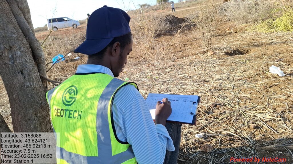
Client/Development Partners: World Bank and UNOPSProject Location: Baidoa, South West State of SomaliaProject: Somalia Urban Resilience Project IIYear: 2025Service Category: Engineering Surveying, Topographic Survey and Infrastructure Data CollectionImplemented by: Geotech Engineering and Consultancy Overview Project Geotech Engineering and Consultancy is proud to contribute professional engineering surveying services to the Somalia Urban Resilience Project in Baidoa, an important urban-development initiative supported by the World Bank and the United Nations Office for Project Services—UNOPS. The project is intended to support the development of safer, more accessible and climate-resilient urban infrastructure. As Baidoa continues to experience rapid population growth, urban expansion and increasing pressure on public services, accurate engineering data is essential for planning roads, drainage systems, public facilities and other critical infrastructure. Our field team conducted surveying activities to collect reliable information about the existing ground conditions, elevations, physical features and proposed infrastructure locations. The information gathered through these activities provides an important technical foundation for design development, construction planning and project implementation. Our Role in the Project Geotech’s assignment focused on professional land-surveying and field-data-collection activities within the identified project areas in Baidoa. Using modern surveying equipment, our team collected accurate coordinates and elevation data required for infrastructure planning and engineering design. The fieldwork included the establishment of survey points, observation of ground levels, identification of existing physical features and recording of site conditions. The survey team worked carefully to ensure that all measurements were properly checked, recorded and prepared for use by engineers, consultants and project stakeholders. Our activities included: Use of Modern Surveying Technology The field survey was carried out using professional surveying instruments, including a total station, together with supporting field equipment. A total station enables surveyors to measure horizontal angles, vertical angles, distances and coordinates with a high level of accuracy. This technology allows our team to collect detailed site information that can later be processed into topographic maps, profiles, cross-sections and engineering drawings. The use of modern surveying technology improved the accuracy and efficiency of the fieldwork while reducing the risk of measurement errors. All recorded observations were checked as part of our quality-control procedures before being prepared for engineering use. Importance of Accurate Survey Data Every successful infrastructure project begins with reliable information about the site. Inaccurate elevations, coordinates or boundary information can create serious problems during design and construction. Accurate topographic data helps engineers understand the natural slope of the land, determine drainage directions, calculate excavation and filling quantities and identify potential construction challenges before work begins. For urban infrastructure projects, survey information can support the design and construction of: By providing accurate survey information, Geotech helps project designers make informed engineering decisions and develop solutions that respond to the actual conditions on the ground. Geotech’s Commitment At Geotech Engineering and Consultancy, we believe that successful infrastructure begins with accurate investigation, reliable survey data and a clear understanding of site conditions. Our work on the Somalia Urban Resilience Project II in Baidoa reflects our continued commitment to: We are proud to support projects that improve urban infrastructure, strengthen resilience and create long-term value for Somali communities. Conclusion The surveying activities undertaken for the Somalia Urban Resilience Project II in Baidoa represent an important step in the planning and development of reliable urban infrastructure. Through accurate topographic surveying, field verification and professional data collection, Geotech supported the creation of a dependable technical foundation for subsequent engineering and construction activities. We appreciate the collaboration of the project stakeholders, local authorities, community representatives and field personnel who contributed to the successful completion of the surveying activities. Geotech Engineering and Consultancy remains ready to support future infrastructure-development projects with professional surveying, geotechnical investigation, materials testing, engineering design and construction-supervision services.